312/1 · GEOGRAPHY · Paper 1 · Nov. 2023 · 2¾ hours
Instructions: This paper consists of two sections, A and B. Answer all the questions in section A. In section B answer question 6 and any other two questions.
Section A (25 marks)
1. (a) Differentiate between weathering and mass wasting. (2 marks)
(b) Identify three ways in which temperature change influences physical weathering. (3 marks)
2. Describe how a land breeze occurs. (5 marks)
3. (a) Distinguish between weather and climate. (2 marks)
(b) State three negative effects of desertification on the physical environment. (3 marks)
4. (a) State two factors that influence river erosion. (2 marks)
(b) Name the three types of sand dunes. (3 marks)
5. Figure 1 shows zones of ground water. Use it to answer question 5(a).
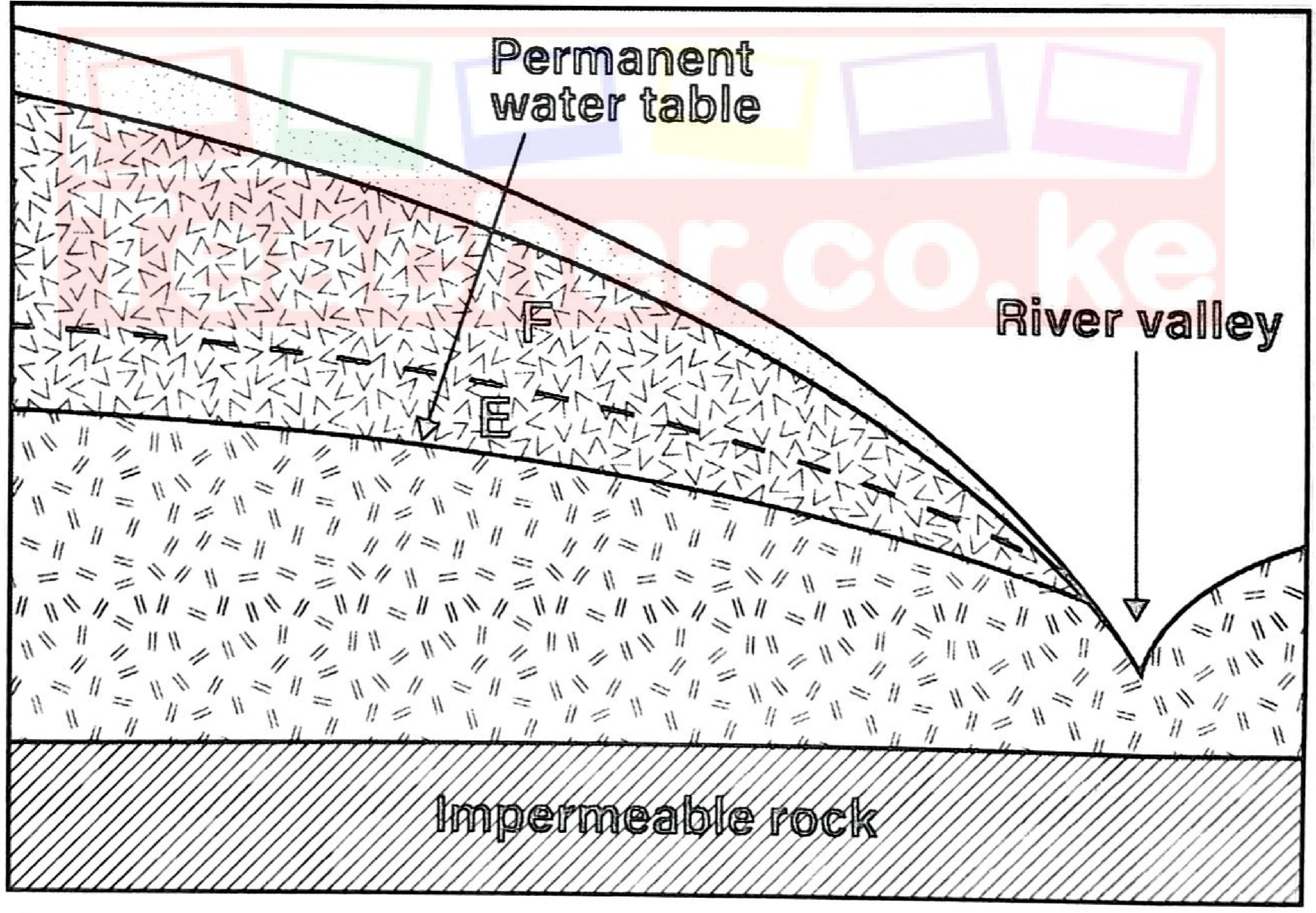
(a) Name the zones marked E and F. (2 marks)
(b) State three conditions that favour the formation of an artesian basin. (3 marks)
Section B (75 marks)
Answer question 6 and any other two questions from this section.
6. Study the 1965 map of Mumias 1:50,000 (sheet 101/2) provided and answer the following questions.
The topographical map is supplied separately in the exam and is not on file here; questions 6(a)(ii), (iv), (b) and (d) need the map.
(a) (i) Convert the scale of the map into a statement scale. (2 marks)
(ii) Give the six-figure grid reference for the school at Mungabo. (2 marks)
(iii) Identify three types of natural vegetation found to the south of Northing 36. (3 marks)
(iv) What is the bearing of the school at Khamashia from the school at Ihonje? (2 marks)
(b) Using a vertical scale of 1 cm to represent 20 m, draw a cross-section from grid reference 580410 to 670410. On the cross-section, mark and name: (i) all-weather road, loose surface; (ii) riverine trees; (iii) River Nzoia; (iv) seasonal swamp. (7 marks)
(c) Citing evidence from the map, explain two factors favouring trading in the area. (4 marks)
(d) Describe the relief of the area covered by the map. (5 marks)
7. (a) (i) Give three sources of lake water. (3 marks) (ii) State three characteristics of lakes formed due to faulting. (3 marks)
(b) Describe how the following lakes are formed: (i) moraine-dammed lake; (ii) lagoon. (11 marks)
(c) Explain four ways in which lakes influence the climate of the surrounding areas. (8 marks)
8. (a) (i) Define the term glaciation. (2 marks) (ii) Explain three negative effects of glaciation on the human environment. (6 marks)
(b) (i) Give three ways in which ice moves. (3 marks) (ii) Explain two factors that influence movement of ice. (4 marks)
(c) Describe how each of the following features is formed: (i) outwash plain; (4 marks) (ii) roche moutonnée. (6 marks)
9. (a) Give two reasons why wind is more active in hot deserts. (2 marks)
(b) Describe how the following features found in hot deserts are formed: (i) mushroom block; (4 marks) (ii) yardangs. (4 marks)
(c) Explain three ways in which features resulting from wind action in arid areas are important. (6 marks)
(d) Some students carried out a field study on wind deposition features in an arid area in Kenya.
(i) Name three secondary sources of information they are likely to rely on while preparing for the study. (3 marks)
(ii) State three reasons why it was necessary for the students to visit the area before the actual field study. (3 marks)
(iii) Give three advantages of studying wind depositional features through field work. (3 marks)
10. (a) Classify soils according to order. (3 marks)
(b) Explain how the following factors influence soil formation: (i) parent rock; (4 marks) (ii) climate. (6 marks)
(c) State five economic uses of soil. (5 marks)
(d) Students in a secondary school intend to carry out a field study on soils within their local environment.
(i) Give three activities the students are likely to carry out during the study. (3 marks)
(ii) List four properties of soil the students would study. (4 marks)