312/1 · GEOGRAPHY · Paper 1 · Nov. 2025 · 2¾ hours
Instructions: This paper has two sections, A and B. Answer all the questions in section A. In section B, answer question 6 and any other two questions.
Section A (25 marks)
1. (a) Give the dates when the sun is overhead along the equator. (2 marks)
(b) State three characteristics of the SIAL layer of the earth's crust. (3 marks)
2. (a) Explain the term rock as used in Geography. (2 marks)
(b) List two examples of plutonic rocks. (2 marks)
3. The following diagram shows a simple fold.
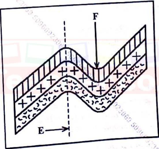
(a) Name the parts labelled E and F. (2 marks)
(b) Give three factors that influence folding. (3 marks)
4. (a) State two ways of measuring the strength of an earthquake. (2 marks)
(b) State three natural causes of earthquakes. (3 marks)
5. (a) Name three soil-forming processes. (3 marks)
(b) Give the three types of soil degeneration. (3 marks)
Section B (75 marks)
Answer question 6 and any other two questions from this section.
6. Study the map of Kipkabus 1:50 000 (Sheet 104/1) provided and answer the following questions.
(a) (i) What was the magnetic variation of the area when the map was drawn? (1 mark) (ii) Name the two types of scale shown on the map. (2 marks) (iii) What is the direction of the Air Photo Principal Point 87 in grid square 8338 from the Trigonometrical Station Primary SKP 1022? (2 marks)
(b) Measure the distance of the dry-weather road from grid reference 867365 to 829420. (2 marks)
(c) Using a scale of 1 cm to represent 20 metres, draw a cross-section from grid reference 785320 to 853320. (3 marks) On the cross-section, mark and label: (i) main track (motorable); (ii) forest boundary; (iii) river; (iv) gentle slope. (4 marks)
(d) (i) Describe the drainage of the area covered by the map. (5 marks) (ii) Citing evidence from the map, explain three economic activities carried out in the area covered by the map. (6 marks)
(The Kipkabus map extract is not reproduced here.)
7. Use the following map of Africa to answer questions 7(a) and (b).
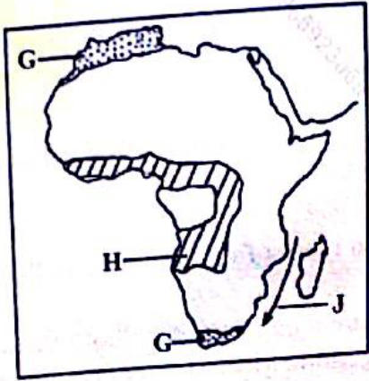
(a) Name the: (i) ocean current marked J; (1 mark) (ii) climatic region marked H. (1 mark)
(b) State the characteristics of the climatic regions marked G. (5 marks)
(c) Explain two ways in which the configuration of the coastline influences climate. (4 marks)
(d) Explain how the equatorial vegetation is adapted to the climatic conditions. (4 marks)
(e) State four pieces of evidence for climate change. (4 marks)
(f) You intend to carry out a field study in a weather station. (i) State two objectives of the study. (2 marks) (ii) Give four activities that you would undertake in preparation for the study. (4 marks)
8. (a) (i) Name two agents of weathering. (2 marks) (ii) State four types of mechanical weathering. (4 marks)
(b) Describe the process of carbonation. (4 marks)
(c) (i) Give three pieces of evidence for soil creep. (3 marks) (ii) State four factors responsible for rapid mass wasting. (4 marks)
(d) Explain four effects of weathering on the environment. (8 marks)
9. (a) (i) Explain the term lake. (2 marks) (ii) Identify three factors that determine the size of a lake. (3 marks)
(b) (i) State two characteristics of lakes formed through crustal warping. (2 marks) (ii) Apart from crustal warping, give four other processes that lead to the formation of lakes. (4 marks)
(c) With the aid of well-labelled diagrams, describe how an ox-bow lake is formed. (8 marks)
(d) Your class carried out a field study of a lake in the local environment. (i) Give three reasons why it was necessary for the students to be organised into working groups. (3 marks) (ii) Identify three methods of data recording that the students used. (3 marks)
10. (a) (i) Differentiate between porous and pervious rocks. (2 marks) (ii) Explain two ways through which precipitation influences ground water. (4 marks)
(b) State three characteristics of a karst landscape. (3 marks)
(c) Explain three ways in which a karst scenery influences human activities. (6 marks)
(d) (i) Describe how the following underground features in a karst scenery are formed: I. swallow hole; (4 marks) II. stalactites. (4 marks) (ii) Apart from stalactites and swallow holes, name two other underground features in a karst scenery. (2 marks)