312/1 · GEOGRAPHY · Paper 1 · Dec. 2022 · 2¾ hours
Instructions: This paper consists of two sections, A and B. Answer all the questions in section A. Answer question 6 and any other two questions from section B.
Section A
1. (a) Give the forces which have contributed to the geoid shape of the Earth. (3 marks)
(b) Name the minerals that make up the core of the Earth. (2 marks)
2. (a) List two examples of extrusive igneous rocks. (2 marks)
(b) Give three characteristics of sedimentary rocks. (3 marks)
3. (a) Apart from aspect, list three other factors that influence the distribution of natural vegetation. (3 marks)
(b) State two ways through which aspect influences the distribution of natural vegetation. (2 marks)
4. (a) What is a mineral? (2 marks)
(b) Classify each of the following rocks according to their formation: (i) marble; (ii) granite; (iii) mudstone. (3 marks)
5. (a) Differentiate soil profile from soil catena. (2 marks)
(b) State three ways in which soil texture is important. (3 marks)
Section B
Answer question 6 and any other two questions from this section.
6. Study the map of Kisumu East 1:50,000 (sheet 116/2) provided and answer the following questions.
The topographical map is supplied separately in the exam and is not on file here; question 6 needs the map.
(a) (i) Give the longitudinal extent of the area covered by the map. (1 mark)
(ii) Name three human-made features in grid square 0193. (3 marks)
(iii) Identify the two methods used to show relief on the map. (2 marks)
(iv) Calculate the area of Kisumu town. Give your answer in square kilometres. (2 marks)
(v) Name two types of natural vegetation found in the area covered by the map. (2 marks)
(b) Draw a square 10 cm by 10 cm to represent the area enclosed by Eastings 00 and 10, and Northings 80 and 90. (1 mark) On it mark and name: (i) all-weather road, bound surface; (ii) River Ombeiyi; (iii) Chiga market; (iv) air photo principal point (04). (4 marks)
(c) Describe the distribution of settlement in the area covered by the map. (4 marks)
(d) Citing evidence, give three economic activities carried out in the area covered by the map. (6 marks)
7. (a) What is faulting? (2 marks)
(b) (i) Apart from the Rift Valley, name three other features that result from faulting. (3 marks)
(ii) With the aid of well-labelled diagrams, describe how the Rift Valley may be formed by compressional forces. (8 marks)
(c) Explain how faulting influences each of the following: (i) drainage; (6 marks) (ii) transport. (6 marks)
8. (a) (i) Name the instruments used to measure each of the following elements of weather: I. humidity; (1 mark) II. atmospheric pressure. (1 mark)
(ii) State three traditional methods of weather forecasting. (3 marks)
(b) The statistical table below shows temperature and rainfall for a given station X in Africa.
| Month | J | F | M | A | M | J | J | A | S | O | N | D |
|---|---|---|---|---|---|---|---|---|---|---|---|---|
| Temperature (°C) | 27 | 27 | 26 | 25 | 23 | 22 | 21 | 21 | 22 | 23 | 25 | 26 |
| Rainfall (mm) | 366 | 376 | 452 | 399 | 264 | 282 | 302 | 203 | 132 | 99 | 117 | 262 |
(i) Calculate the: I. annual range of temperature; (2 marks) II. total annual rainfall. (2 marks)
(ii) Describe the climatic conditions of station X. (4 marks)
(c) Explain how ocean currents influence the climate of adjacent coastal land. (6 marks)
(d) Explain three measures that can be taken to control desertification. (6 marks)
9. (a) Apart from landslides, list the other two forms of rapid mass wasting. (2 marks)
(b) Explain how each of the following factors facilitates mass wasting: (i) nature of rock material; (4 marks) (ii) human activities. (4 marks)
(c) Explain the effects of mass wasting on the environment. (8 marks)
(d) You intend to carry out a field study in an area affected by landslides within the vicinity.
(i) Give three reasons why it is important to seek permission from the school administration. (3 marks)
(ii) State the advantages of studying landslides through fieldwork. (4 marks)
10. (a) (i) Name two mountains in East Africa that are ice-capped. (2 marks) (ii) Give two types of moraine. (2 marks)
(b) The diagram below represents an upland glaciated landscape. Use it to answer question 10(b)(i).
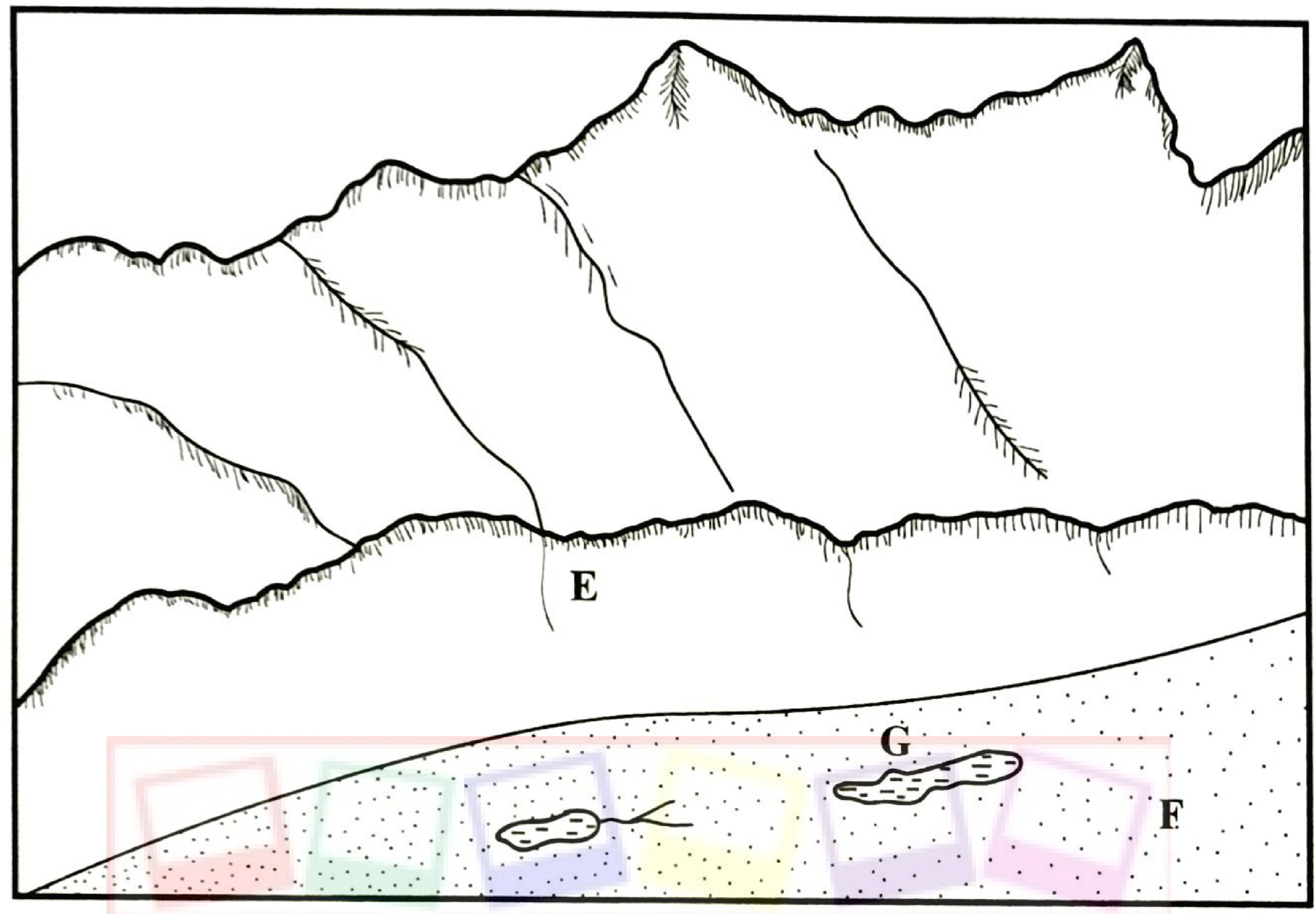
(i) Name the features marked E, F and G. (3 marks)
(ii) Describe how each of the following features is formed: I. pyramidal peak; (6 marks) II. crag and tail. (6 marks)
(c) Explain the significance of glaciated upland areas to human activities. (6 marks)