312/2 · GEOGRAPHY · Paper 2 · Dec. 2022 · 2¾ hours
Instructions: This paper consists of two sections, A and B. Answer all the questions in section A. Answer question 6 and any other two questions from section B.
Section A
1. (a) State three conditions that are necessary for the formation of petroleum. (3 marks)
(b) Give two by-products of petroleum. (2 marks)
2. (a) Define agriculture. (2 marks)
(b) Give three social factors which influence agriculture. (3 marks)
3. (a) Apart from draining of swamps, give three other methods through which land has been reclaimed in Kenya. (3 marks)
(b) Identify two methods that are used to drain swamps in Kenya. (2 marks)
4. State four ways in which bush fires negatively affect wildlife in East Africa. (4 marks)
5. (a) Give three factors that favour the establishment of National Parks in the semi-arid areas of Kenya. (3 marks)
(b) State ways in which ecotourism has led to a sustainable tourism industry in Kenya. (3 marks)
Section B
Answer question 6 and any other two questions from this section.
6. The sales (in tonnes) of selected crops grown in Kenya between 2015 and 2017 are represented in the table below.
| Crop | 2015 | 2016 | 2017 | Total |
|---|---|---|---|---|
| Tea | 399,200 | 473,000 | 439,900 | 1,312,100 |
| Maize | 295,300 | 265,800 | 239,200 | 800,300 |
| Wheat | 227,300 | 215,900 | 156,900 | 600,100 |
Source: Economic Survey 2018
(a) (i) Calculate the percentage decrease in sales of wheat between the years 2015 and 2017. (2 marks)
(ii) Give four reasons that may have led to the decrease in wheat sales between 2015 and 2017. (4 marks)
(b) (i) Draw a pie chart to represent the data on selected crop sales shown in the table. Show your calculations. (7 marks)
(ii) Give three advantages of using a pie chart to represent geographical data. (3 marks)
(c) (i) Name three counties in Kenya where wheat is grown on a large scale. (3 marks)
(ii) Explain three physical conditions that favour wheat growing in Kenya. (6 marks)
7. (a) Name two categories of inland fresh water fisheries in East Africa. (2 marks)
(b) The map below shows some major fishing grounds of the world.
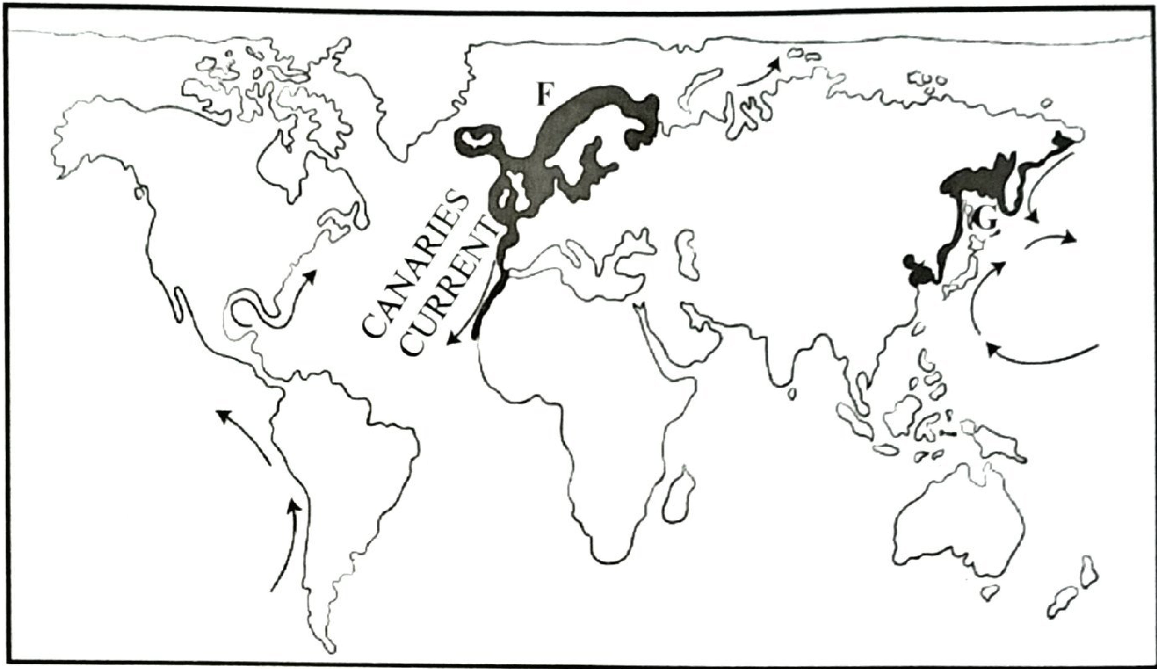
(i) Identify the shaded fishing grounds marked F and G. (2 marks)
(ii) Explain three physical conditions that favour fishing in the ground marked G. (6 marks)
(c) (i) Name two fishing methods used in small-scale fishing in Kenya. (2 marks)
(ii) Describe how the trawling method is used in fishing. (5 marks)
(d) Explain four ways in which fresh water fisheries are conserved in Kenya. (8 marks)
8. (a) (i) Identify three renewable sources of energy. (3 marks) (ii) State five disadvantages of using coal as a form of energy. (5 marks)
(b) (i) What is an energy crisis? (2 marks) (ii) Explain four ways in which an energy crisis affects the economy of Kenya. (8 marks)
(c) Some students carried out a field study on uses of energy by sampling the households around their school.
(i) State three reasons why the students would be divided into groups. (3 marks)
(ii) Identify two sampling techniques that the students may have used during the field study. (2 marks)
(iii) Give two advantages of sampling the households for the study. (2 marks)
9. (a) (i) Give three examples of agricultural non-food processing industries in Kenya. (3 marks)
(ii) State five ways in which government policy influences the location of industries in Kenya. (5 marks)
(b) (i) Give five characteristics of the cottage industry in India. (5 marks)
(ii) Explain three problems facing Jua Kali industries in Kenya. (6 marks)
(c) You intend to carry out a field study in an industry within the local environment.
(i) Give two sources of secondary data you will refer to before conducting the field study. (2 marks)
(ii) Identify four benefits of the industry to the local community that you are likely to find out during the study. (4 marks)
10. (a) (i) What is transport? (2 marks) (ii) Name two international airports in Kenya. (2 marks) (iii) Give four advantages of air transport over road transport. (4 marks)
(b) State five benefits that would result from improving the conditions of roads in rural areas of Kenya. (5 marks)
The sketch map below shows the Great Lakes and the St. Lawrence Seaway. Use it to answer question (c).
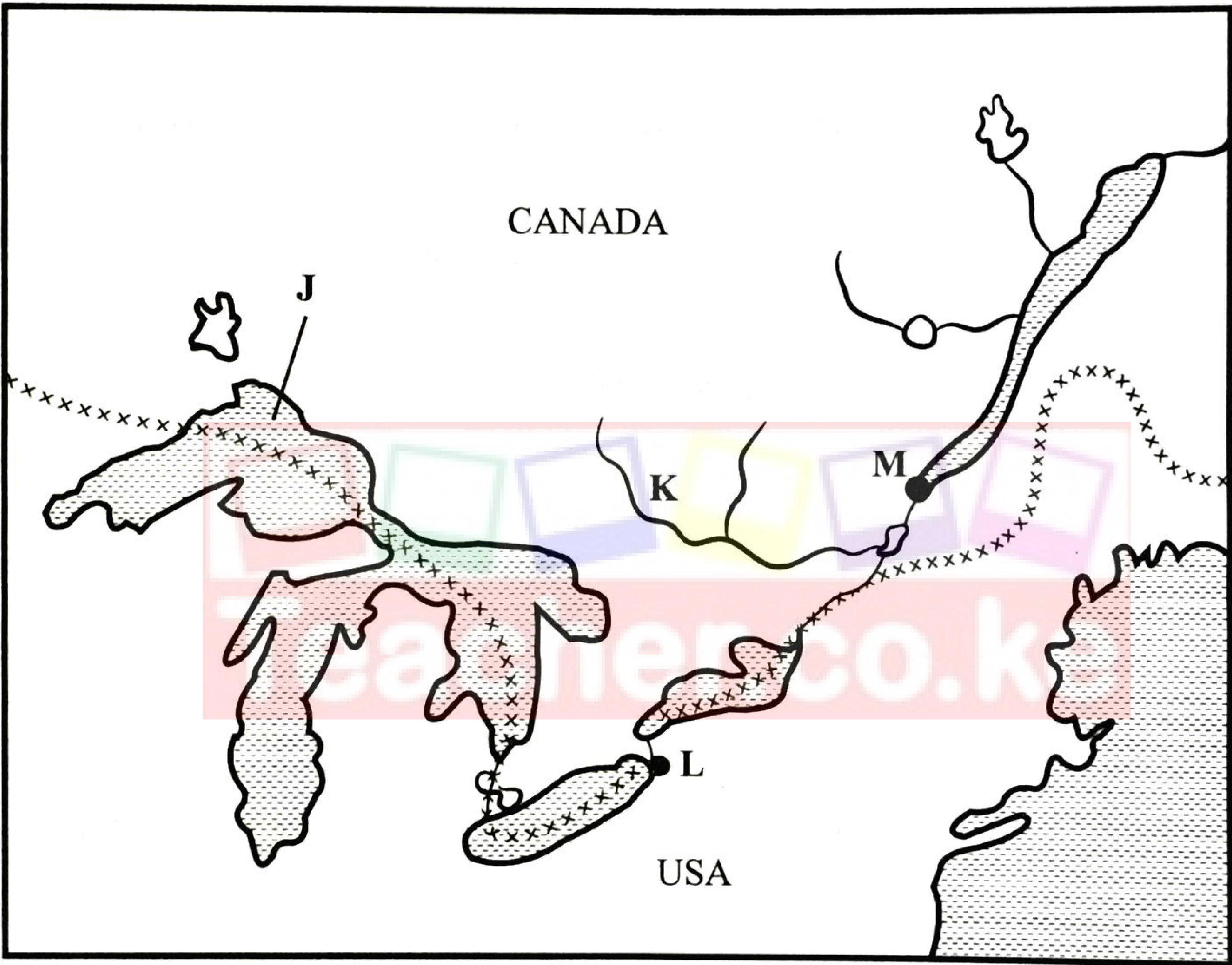
(c) Name: (i) the lake marked J; (1 mark) (ii) the river marked K; (1 mark) (iii) the ports marked L and M. (2 marks)
(d) Explain four ways in which the Great Lakes and the St. Lawrence Seaway have contributed to the economies of the United States of America and Canada. (8 marks)